If there is anything that anyone involved in mining in the old west had
to know, it was all that legal stuff! From the initial claim notice, filing the claim, working the claim, and holding on to
the claim, there were uncounted ways that you could loose your workings to another.
This is where the lawyers come in. Everybody had one, needed one, or in some cases wished they had one. After
all, all that legal stuff meant paperwork, a lot of paperwork. It all had a purpose, and it all cost money! Recorders, clerks,
surveyors, engineers, counties, states, courts, insurance companies, and even the federal government all had a wonderful selection
of documents that just had to be filled out, and filled out properly.
As you look over this selection of legal documents, remember that old saying "Dot your i's and cross your
t's", it's important!
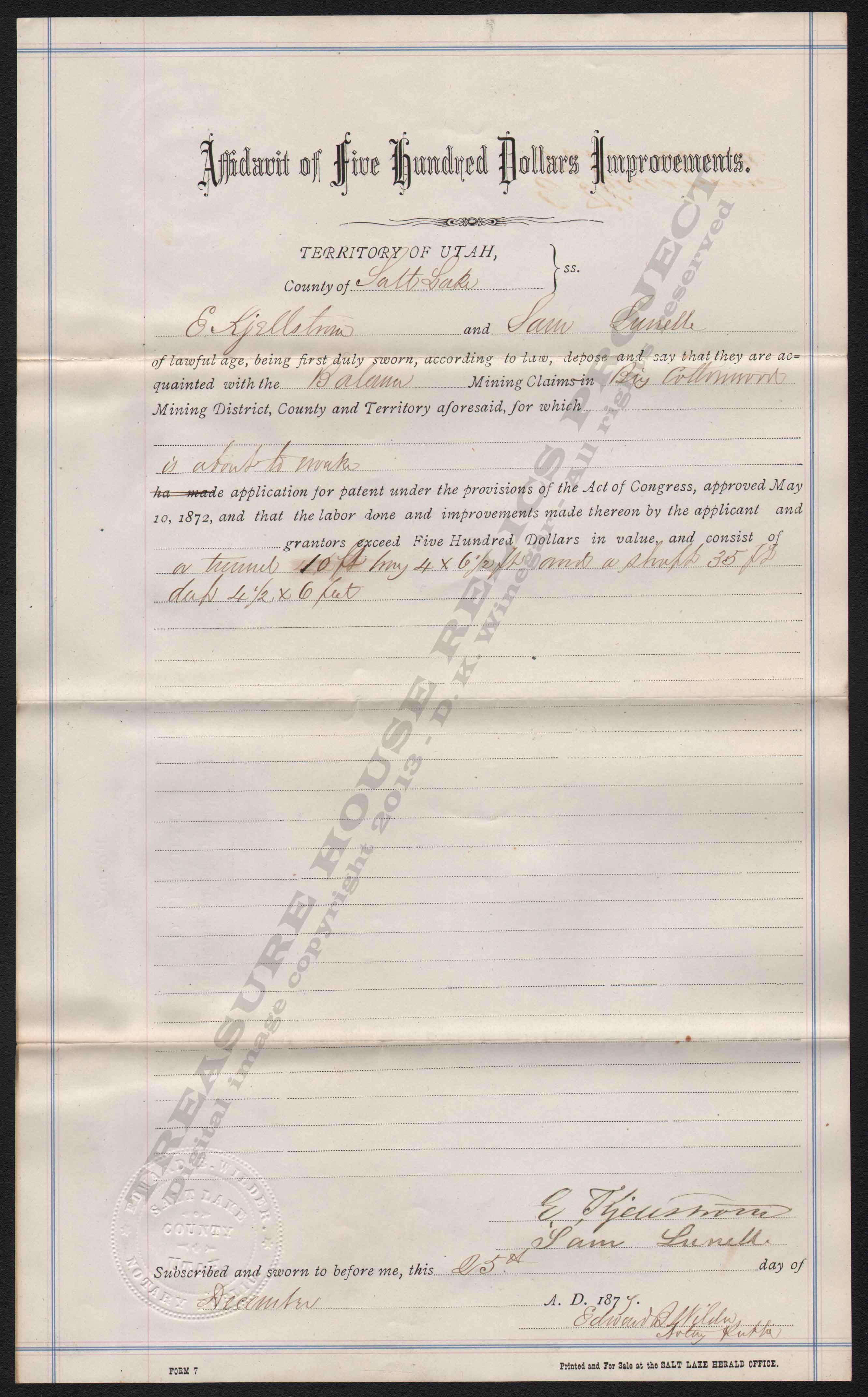
Affidavit of Five Hundred Dollars
Improvements
(Territorial Document)
Below is a copy of a "Affidavit
of Five Hundred Dollars Improvements". This document was required to be filed as a
part of the early land Patenting process. Along with claiming, surveying, and other requirements, proof of labor and/or improvements
had to be stated and certified.
In this case we have E.Kjellstrom? and Sam Sunelle detailing the exact improvements that have been done on
the Balamer Lode Claim in Salt Lake Counties' Big Cottonwood District. The improvements include "A tunnel 10 ft. long, 4 x 6 1/2 ft and
a shaft 35 ft. deep 4 1/2 x 6 feet."
Notary Public Edward Wilder has witnessed
this document and affixied his seal and signature. This document dates from 1877.
THRP Archive - THRP Collection
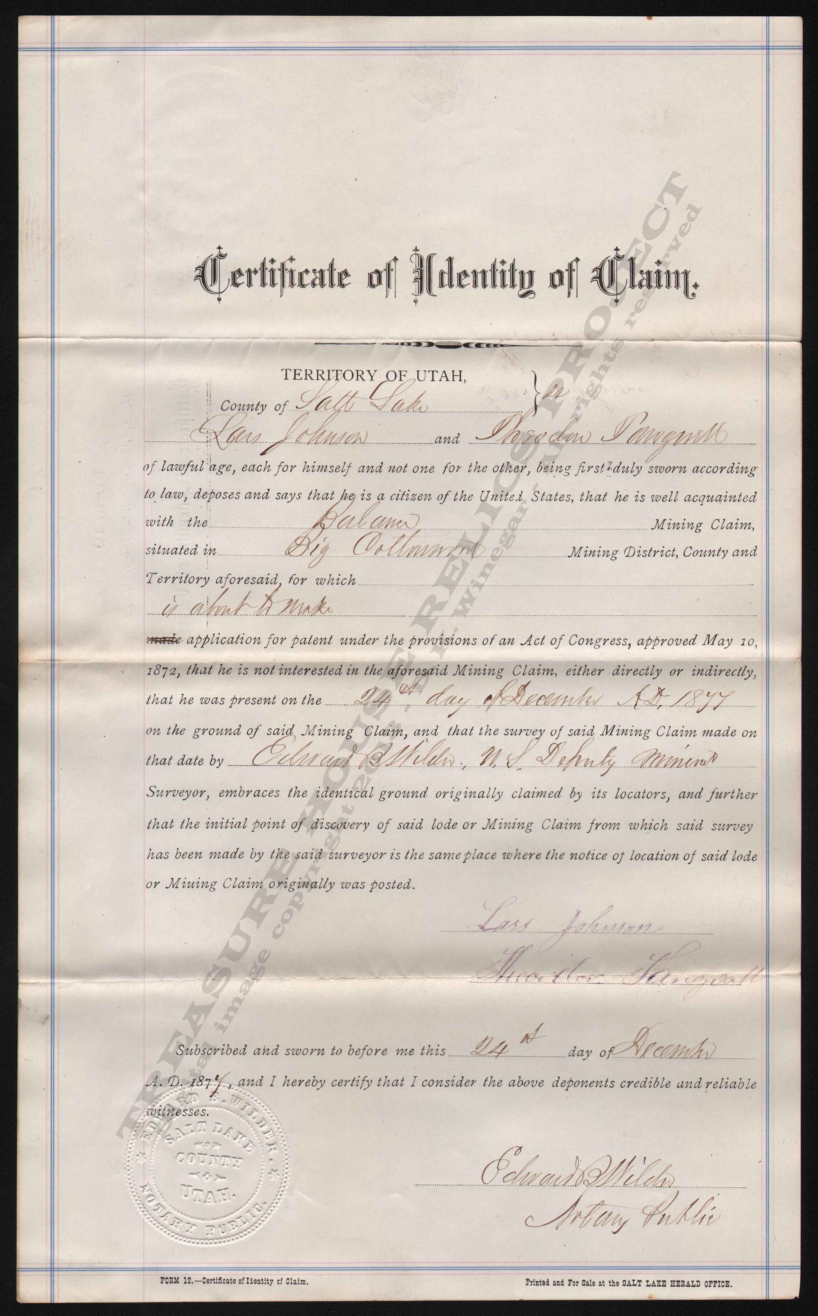
Certificate of Identity of Claim (Territorial Document)
Below is a copy of a "Certificate of Identity of Claim". This
document was required to be filed as a part of the Land Patent application process. It was a legal way of saying "This
is the name of the claim we are requesting a patent on". It required signatures of not only the requestors, but a notary
as well.
In this case we have Lars Johnson and Theodore
Tangvall? requesting the patent for their Balamer Lode Claim in Salt Lake Counties' Big Cottonwood District, with Notary Public
Edward Wilder witnessing this document and affixing his seal as to the identity and information on the form. This document
dates from 1877.
THRP Archive - THRP Collection
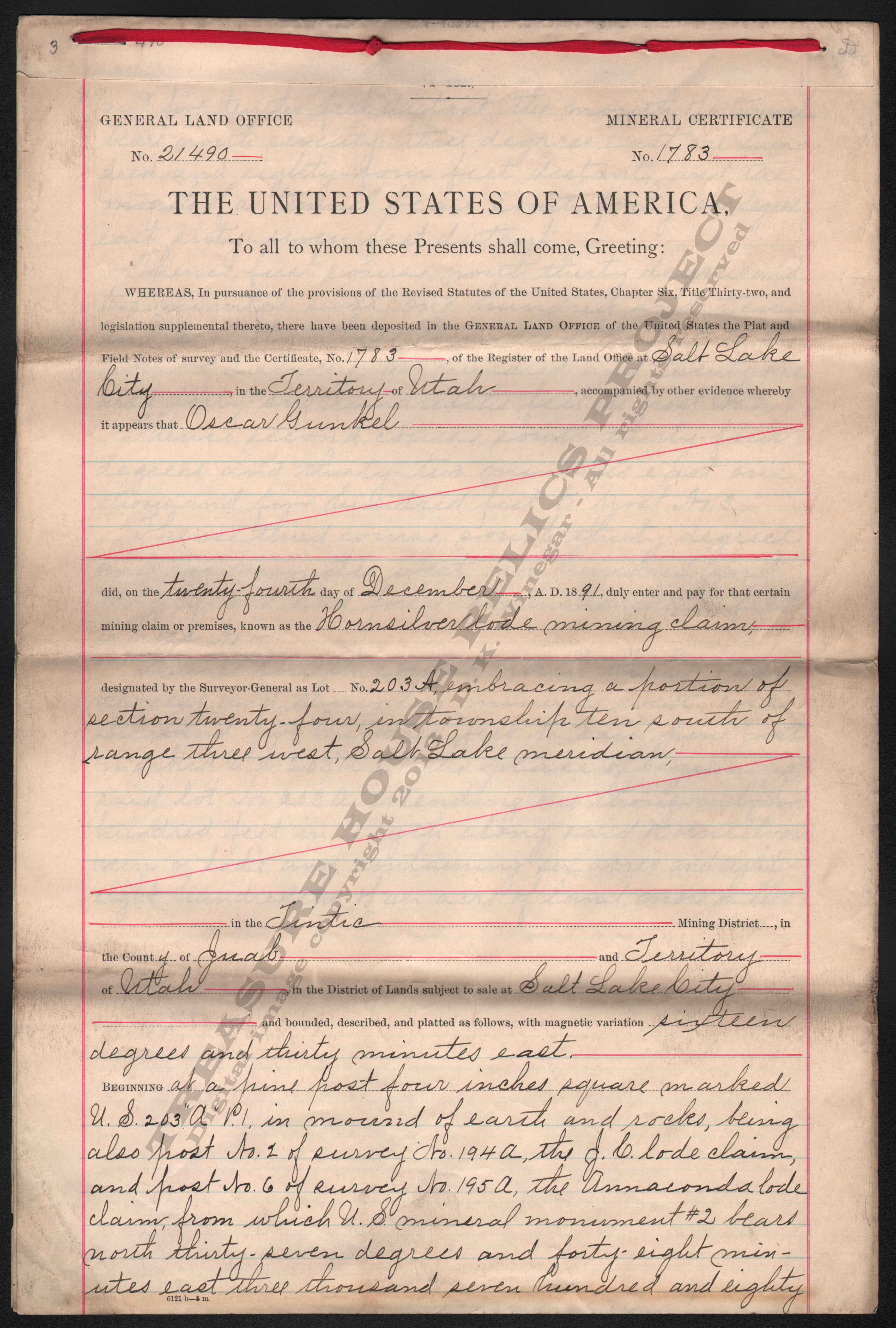
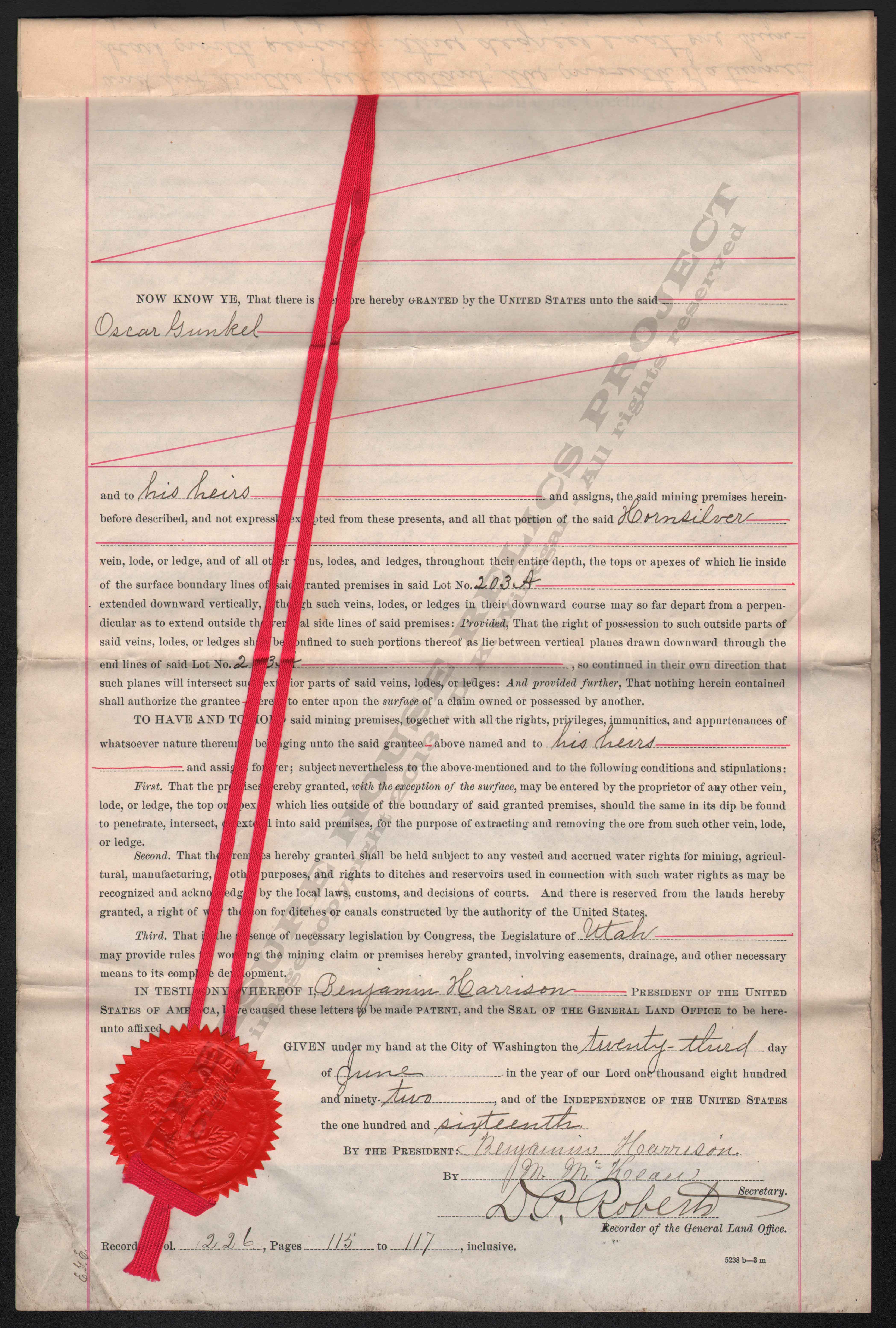
Mineral Certificate (Land Patent)
(Federal Document)
Below is a copy of a "Mineral
Certificate" or Land Patent Certificate. This document was issued by the United
States General Land Office in the final step of the early land patenting process. The document listed in detail the name of
the patent holder, the claim, the location, and all information related to the property.
In this sample, we have a three page mineral certificate
#1783 issued to Oscar Gunkel of Salt Lake City, Territory of Utah. The certificate is issued for the Hornsilver Lode Mining
Claim in the Tintic District, Juab County. Along with the exact legal description of the mineral property, the document clearly
stated that the land was now private property of the issuee and his heirs...to have and hold.
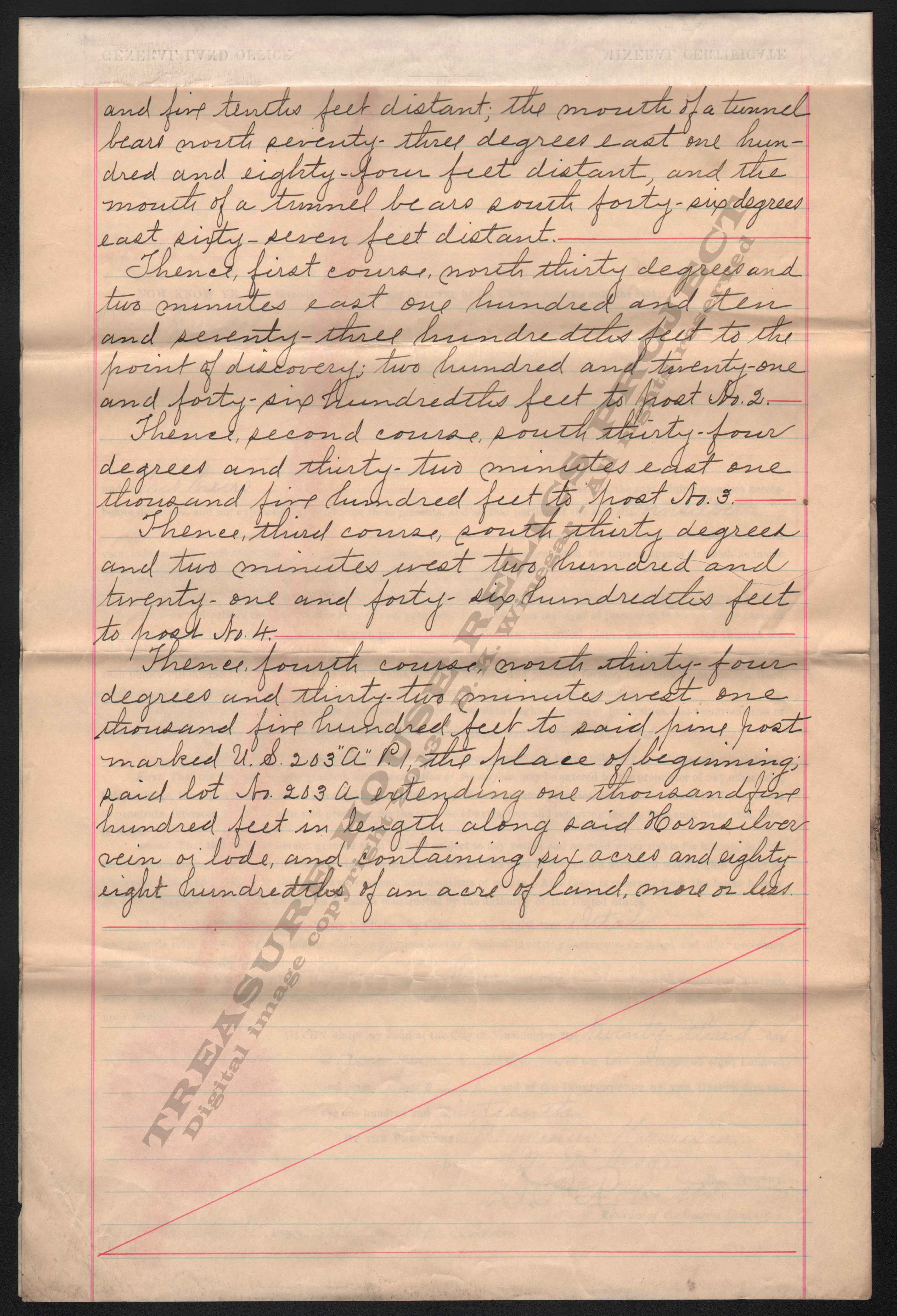
As
with any mineral certificate, the document was issued under the signature of the office of the President of the United States.
In some cases, the document was actually signed by the president at the time, but in most cases the documents were signed
by the president's secretary or agent. With this sample the document was signed in the name of President Benjamin Harrison
by his Secretary M. McKean. The document is also signed by D. P. Roberts, Recorder of the General Land Office.
In
addition to the signatures, the last page of this document is adorned with colored cloth ribbon and a red embossed seal. This
document was issued June 23rd, 1892.
THRP Archive - THRP Collection
THRP Archive - THRP Collection
THRP Archive - THRP Collection
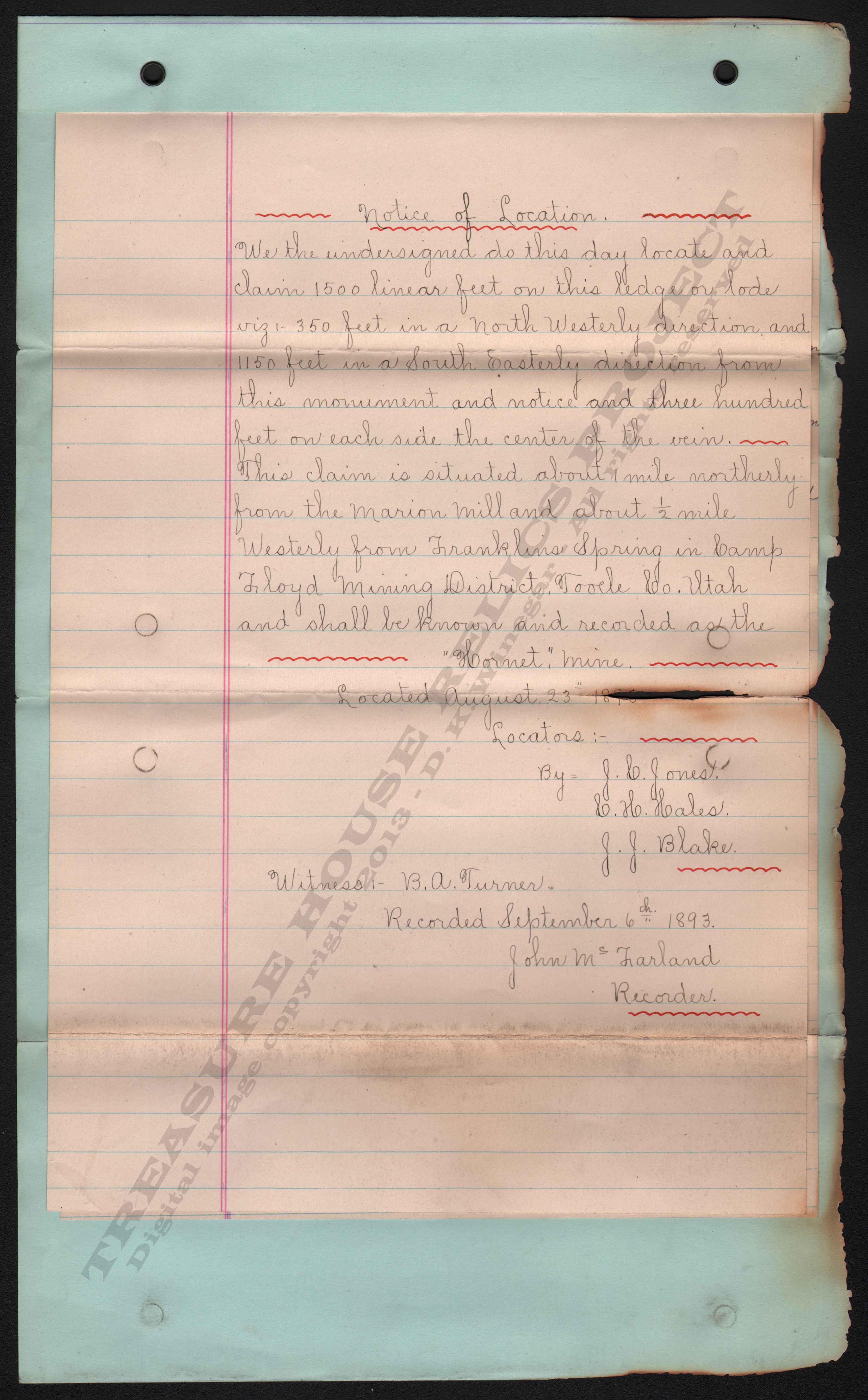
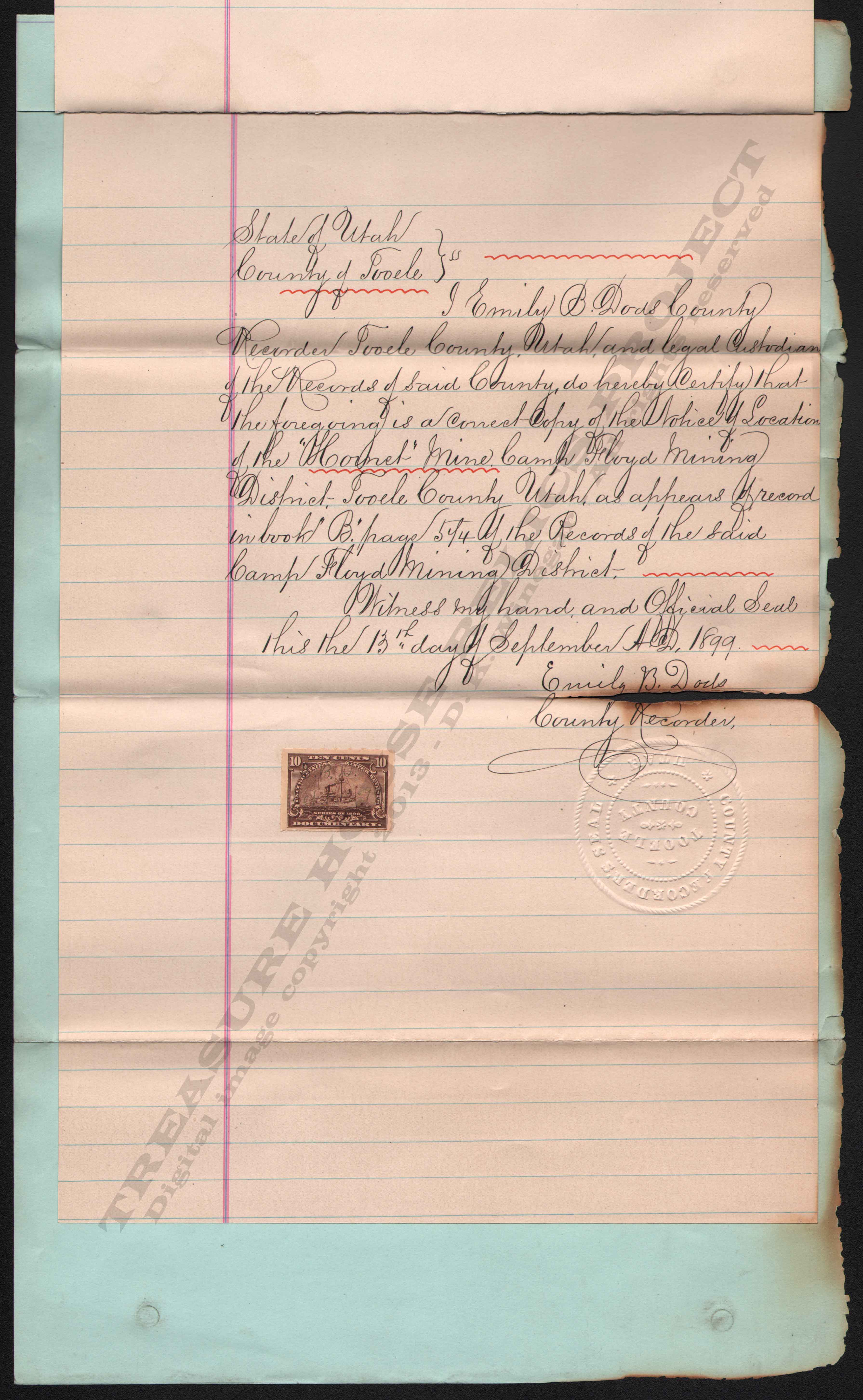
Notice of Location (Territorial Document)
Below is the image of a "Notice of Location". This document was required to be filed
with the mining district recorder within a specific time frame after the initial claim discovery and marking. The time allowed
to file this legal document varied by district an their specific by-laws.
The notices had to include the names of the claiments, name of the claim, location of the claim, size of the
claim, and most importantly, the date of the claim. Dates would play a critical part in legal battles that would arise over
a huge number of mining claims in the old west, and even today can still plague mining men.
Back then, there was no way for the simple miner to know the exact legal location of a property, so nearby landmarks
or commonly known sites were used. In this case the locators used the Marion Mill and Franklin's Spring as nearby landmarks.
Only after the property was shown to be valuable, would miners or companies pay to have a formal survey made.
This Notice of Location covers the "Hornet
Mine" in the Camp Floyd Mining District, near the old boom town of Mercur. This certified
copy dates from 1899, the original claim was made in 1893.
THRP Archive - THRP Collection
THRP Archive - THRP Collection
Notice of Location
- Josephine Claim (Rush Valley District)
This Notice of Location covers the "Josephine
Claim" claim in the Rush Valley District, Tooele County, Utah Territory. The notice
is dated June 20th, 1870 and recorded July 8th, 1870, just a few weeks later.
This
notice is one of the ealiest here in the archive, and is one that is completely hand written. This notice states that the
claiments herby "relocated"
this ground. Most of the initial claims made by Patrick Connor and his soldiers in the 1860's, were reclaimed in the early
1870's once the civil war was over. There will be more about this in the months to come.
Notice of Location
- King Bee Claim (Utah Silver Diatrict)
This Notice of Location covers the "King
Bee Claim" claim in the Utah Silver District, near Ogden, Utah. This notice shows
a number of locators and is dated March 10th, 1871. The notice was recorded in the district books on April 19th, not quite
a month later.
Notice of Location
- Star Light Claim (Camp Floyd District)
This Notice of Location covers the "Star
Light Claim" claim in the Camp Floyd District, Tooele County, Utah Territory.
The notice is dated May 1st, 1895 and recorded May 30, a few weeks later. It is also worth noting that this particular notice
was printed on the presses of the Mercur Mercury, the short-lived newspaper of the districts one-time largest city, Mercur.
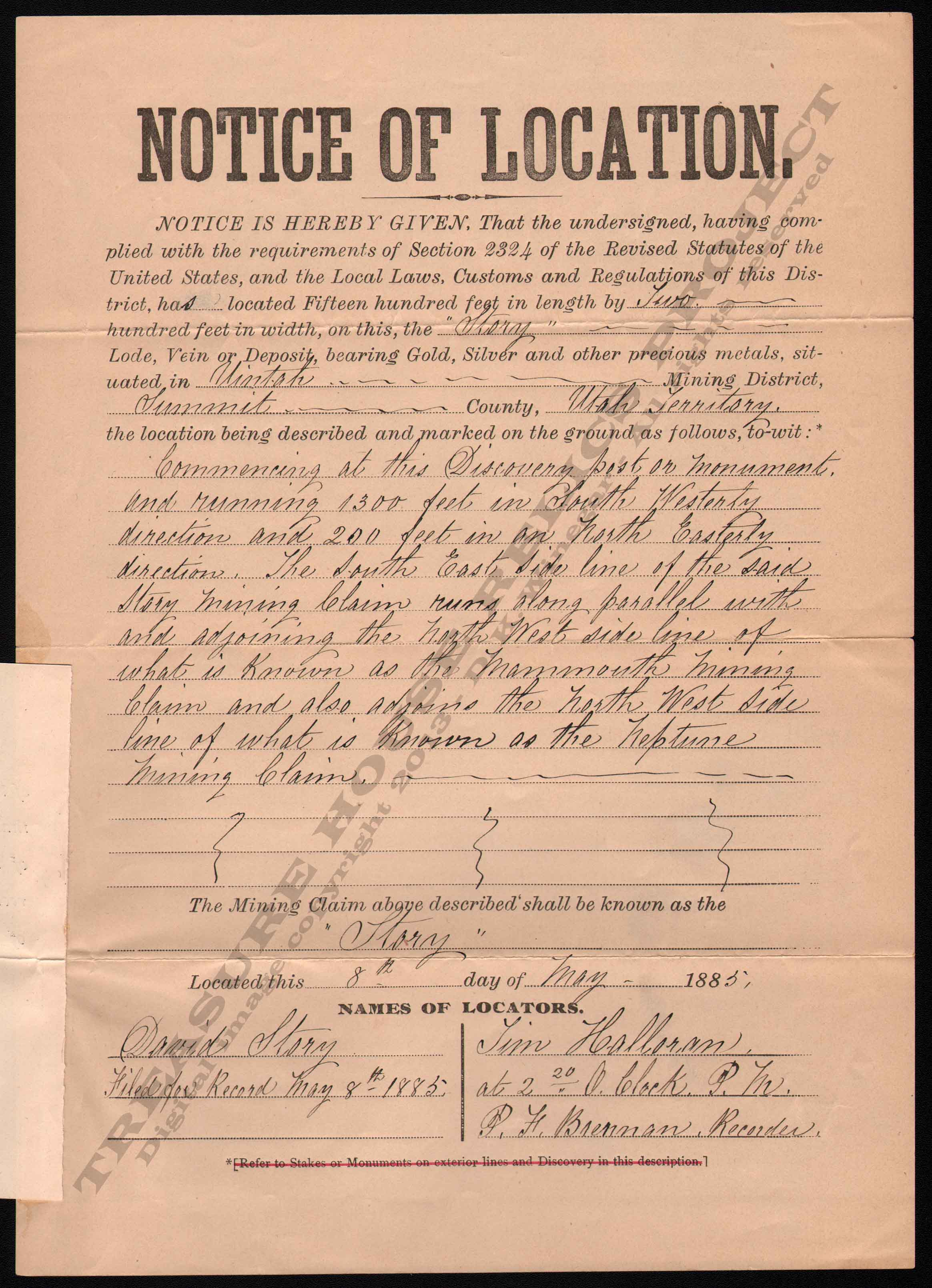
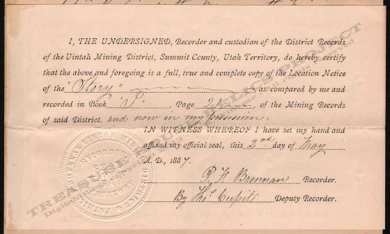
Notice of Location - Story Claim (Territorial Document)
Below are the images of a "Notice of Location" and "Recorder's
Certificate" This document is
certified copy of the original documents filed with the district recorder.
This Notice of Location covers the "Story" claim in the Uintah Mining District, near Park City. This certified copy dates from 1887, the original
claim was made in 1885.
The second document is a Recorder's
Certificate. This is an original signed and seal embossed document certifying that the other document was a "full, true and complete
copy of the Location Notice". This document
is signed by Thomas Cupit the Deputy Recorder on behalf of Patrick F. Brennan, the true Uintah District Recorder.
THRP Archive - Winegar Collection
THRP Archive - Winegar Collection
Notice of Location
- Sunrise Claim (American Fork District)
This Notice of Location covers the "Sunrise
Claim" claim in the American Fork District, in Utah County. This notice shows
the locators to be J.B. Clark and Ben Pearson and is dated October 7th, 1911. The notice was recorded in the district books
on November 3, 1911.
Notice of Location
- Waterman Lime Stone Ledge Claim
(Rush Valley District)
This Notice of Location covers the "Waterman
Lime Stone Ledge" claim in the Rush Valley District, near Stockton, Utah. This
notice dates from 1886.
_____________________