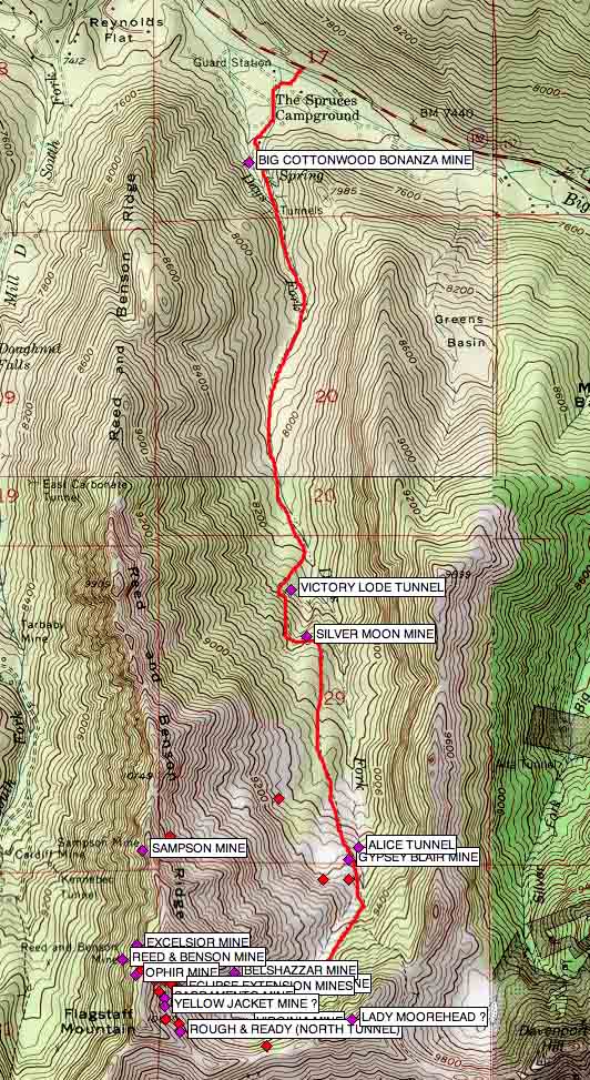
The next fork east of Mill D South Fork in Big Cottonwood Canyon,
is Days Fork. This fork had little mining activity compared to other side canyons, with most of that activity located near
the head of the canyon and divide with Little Cottonwood Canyon.
Early operations were plentiful if not substantial. Prospect
holes and adits doted the hillside in this upper canyon. Colorful names and claims included the Eclipse, Rough & Ready,
Belshazzar, Yellow Jacket, Gypsy Blair, Lady Moorhead, Alice, and Virginia among others. Of those, It was the Eclipse and
the Gypsy Blair that would be two of the most notable over time.
Near the head of the canyon a small bowl shaped ampitheater turns
to the south-west. The Gypsy Blair is located just below where this turn begins, the Eclipse farther up in the bowl on the
north slope.
| TOPO! COPYRIGHT 2010 NATIONAL GEOGRAPHIC |
|
Map
created using TOPO! mapping software from National Geographic.
"TOPO! Copyright 2010 National Geographic"
www.topo.com
Getting there
Access to Days Fork trail head is by way of The Spruces campground, just above Reynolds Flat,
and exactly 10 miles from the stoplight at the mouth of Big Cottonwood Canyon.
There is a fee to park
in the campground lot, but parking along the main canyon road is allowed, and free. Having said that, there are nice restroom
facilities at the campground near the trailhead, so if you use them, it is only fair that you pay the day use fee for the
campground area.
After parking, cross the lot to the south-west towards the mouth of the canyon. The Days
Fork trail begins here.
Click on the link below to go directly to that site page.
