Unknown early sawmill in operation, possibly the Silver Fork operation
at Mill F Flat c.1860's or 1870's. Original image was acquired with a number of other early Big Cottonwood Canyon items -
THRP - Winegar Collection
Location data
QUICK LOCATION PATH: Utah / Salt
Lake County / Big Cottonwood District / Big Cottonwood Canyon / Silver Fork
|
Approximate GPS Location:
|
40.37.982 N - 111.36.681 W (topo) |
|
|
Approximate Elevation:
|
7748' (topo)
|
|
|
30 x 60 Minute Map:
|
SALT LAKE CITY, UTAH
|
|
|
7.5 Minute Map:
|
PARK CITY WEST, UTAH
|
|
Brief history
Silver Fork is one of the last forks branching to the south in Big
Cottonwood Canyon before reaching Brighton and Silver Lake. Silver Fork, the canyon, is today best known for the large concentration
of summer homes and family cabins at its mouth that is Silver Fork, the town. From the present day tree covered appearance you would hardly guess that this area began
as a base for early logging operations. It would be more than 20 years before mining would play a part in the area's history. Logging began shortly after the arrival of the pioneers in 1847, by 1854 the
Big Cottonwood Lumber Company was in operation with two saw mills and a shingle mill. The mills were located on the flats
at the mouth of Silver Fork. A small community of log buildings quickly sprang up around the operation, all there to support
the mills and lumbermen who worked them. In time the sawmills relocated and the town was partially abandoned. By 1870, the one time logging camp became a mining camp. It didn't take long for the flurry
of activity in Little Cottonwood Canyon at Alta to spill over the ridge and into the tops of Silver and Honeycomb Forks. With
that activity, and the rush that accompanied it, the town came to life, supporting the mines just as it had the loggers previously.
A small smelter was constructed, another hotel, commercial buildings, and the once abandoned cabins, became homes again. This second life of the town would be short lived, as the mining boom ended by the mid 1880's.
Some mining did take place after this time, but larger mills and smelters in the valley and improved transportation methods
combined to set Silver Fork up for its second abandonment. In
1893, the area was homesteaded by Joy Dunyon who ran sheep in the fork for many years. Around 1925, the Dunyon family who
still owned the property, subdivided the land, and the present community of Silver Fork with its many summer homes and mountain
cabins came to be.(1) The third life of the town has never ended, and the fork
has been a hiking destination in the summer, and a back country skiing area in the winter. It is the skiing that may most
directly affect the town and the futuer of Silver Fork. A fourth life to the area may be in the works. Just this year (2010) Solitude Ski Resort made application
to expand their ski resort operations into Silver Fork. At least a part of it. The original application that would have opened
the entire fork, some 463 acres, was withdrawn or denied, depending on who you talk to. A second, smaller impact application
was then submitted. This application would open 182 acres, pretty much the entire east face of the fork from the ridge with
Honeycomb Fork down the slope to within 100 feet of SIlver Creek along its entire length.(2) If this access were granted, it would
encompass almost all of the historic mining sites in Silver Fork, including the Prince of Wales, Wellington, and others. What
remains may have to be "reclaimed" to make it safe for the rest of us. If the state does this work, it usually means
destroying it. I hope that preservation would be mandated as a part of any permit, but that is a battle yet to be fought. While that third life goes on, the fourth life being argued, the second life is the focus
of this work; the mining boom. 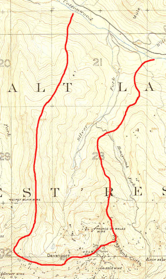 Detail of a 1907 USGS Topographical "Cottonwood Special Map"
showing the Silver Fork area of Big Cottonwood Canyon. The red line has been added to show the approximate area and follows
the ridge lines between Silver Fork and the surrounding forks. Note the concentration of mining locations in the upper bowl
just below Davenport Hill. The only named mine in the fork on this map is the Prince of Wales, though many other shafts and
adits are shown. - THRP - Winegar Collection
A fourth life to the area may be in the works.
Just this year (2010) Solitude Ski Resort made application to expand their ski resort operations into Silver Fork. At least
a part of it. The original application that would have opened the entire fork, some 463 acres, was withdrawn or denied, depending
on who you talk to. A second, smaller impact application was then submitted. This application would open 182 acres, pretty
much the entire east face of the fork from the ridge with Honeycomb Fork down the slope to within 100 feet of SIlver Creek
along its entire length.(2) If this access were granted, it would encompass almost all of the historic mining sites in
Silver Fork, including the Prince of Wales, Wellington, and others. What remains may have to be "reclaimed" to make
it safe for the rest of us. If the state does this work, it usually means destroying it. I hope that preservation would be
mandated as a part of any permit, but that is a battle yet to be fought. While that third life goes on, the fourth life being argued, the second life is the focus
of this work; the mining boom. One of the earliest
mines in the entire territory to have a steam compressor, the Wellington, is found in Silver Fork as well as the Prince of
Wales, Antelope, Highland Chief, Boston Tunnel, Alta Tunnel, Star Tunnel, Warrior, Lucky Dutchman and more. Silver Fork is also the access-way for a large branch fork to the east and south, Honeycomb
Fork. For purposes of this web-site, we will consider Honeycomb Fork as a separate canyon. Silver Fork has no structures that remain standing from those early days, but there is hardware,
some of it partially buried, but visible nonetheless. That which can be seen, shows the beauty and craftsmanship of those
metal workers who designed and built the machinery of mining. HONEYCOMB FORK - Big Cottonwood
LOST EMMA TUNNEL
PAGE TUNNEL COMPANY
PRINCE OF WALES MINE
References:
(1) Carr, Stephen L., Historical Guide to Utah Ghost Towns, Western Epics, Salt Lake City, Utah, 1972
(2) "Solitude Scales Back Silver Fork Proposal", web article, utahoutside.com, 2010
_____________________
|
|
