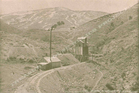
Hoist
house, ore bins, and incline shaft portal of the Sacramento Mine c.1898 - THRP - Winegar Collection
Location data
QUICK LOCATION PATH: Utah / Tooele
County / Camp Floyd District / Mercur or Lewiston Canyon / Mercur
|
Approximate GPS Location:
|
40.18.769 N - 112.12.496 W (topo) |
|
|
Approximate Elevation:
|
7115' (topo)
|
|
|
30 x 60 Minute Map:
|
RUSH VALLEY, UTAH
|
|
|
7.5 Minute Map:
|
MERCUR, UTAH
|
|
Brief history
The Sacramento Mine was one of the early producers
of the district and ajoined the Mercur mine on the south. Located at the head of Sacramento Gulch between Mercur Hill and
Sunrise Hill, the mine had at least one adit and one inclined shaft working the property. The Sacramento was also served by
the rail lines of the Union Pacific (Salt Lake & Mercur) Railroad.
Getting there
Mercur Canyon is closed to access at this time. The site of the original mine no longer exists. The land was
open pit mined by Barrick-Mercur and other companies and is now in the process of being reclaimed. Once the reclaimation work
is complete, it is not known if the old site will be marked or identified in any way.
What remains
Nothing.
______________________